2018年9月6日木曜日

黄龍 シリーズ③ 五彩池へ向かう"Huanglong series(3) Five color schemes of ponds."

黄龍入口からロープウェイで展望台に登りましたが

そこから約2.5km森の中を歩いて、五彩池を目指します

An observatory was climbed by ropeway from a Huanglong entrance.

I walk in the forest from there and aim at five color schemes of ponds.

この辺りは、前回に森林限界の標高が高いと申しましたが

どうも3500~3700mくらいが森林限界の様で、夏でも木陰をあるくことが出来ました

This part said that an altitude of the forest limit was high in last time.
Somehow 3500~~about 3700 m seemed to be the forest limit and it was also possible to walk the shade of a tree in summer.

時折覗く、黄龍独自のカルスト地形の中の流れと湖沼群

The Huanglong at which I now and then look stealthily, personal flow in the karst and lakes and marshes cluster.


木々の合間からは、高い峰が連なって見える

The expensive back ranges and is seen from the intervals of the trees.


緑の森の中で、赤い実が、とても印象的でした

Red fruit was very striking in the green forest.


おそらく、木々にいろんな実をみのらせているので、動物もたくさん生息しているのではないかと思います

Perhaps various fruits are seen and I'm making them take part in the trees, so I think many animals may also live.


五彩池に近づくと、古く朽ちかけた寺が上から見えます

When I approach a pond, five color schemes of temple I have begun to die where looks old from the top.


黄龍は、高い山々に囲まれた谷に位置していることがよくわかります

I find out well that a Huanglong is located in the valley circled by the high mountains.


向こうに見えているのは雪宝頂の一部ですが

この向こう側は白く雪をかぶっています(万年雪で氷河もあります)

It's the part of the Xuebaoding that they see.
This other side wears snow in white (There is also a glacier by eternal snow.)


ズームしてみるとところどころに雪を残しているのが見えます

When a zoom lens will be done, I see leaving snow for places.

いよいよ五彩池のエリアに差し掛かっています

Face to area in five color scheme pond increasingly.

向こうに見えるのは、黄龍古寺

It's a Huanglong old temple that they see.


もうすぐ五色の池が見えてきます

Five colors of pond is being seen soon.


お楽しみは次回までお待ちください

Please wait a moment until next time pleasantly.


2018年9月4日火曜日

沖縄シリーズ③ 観光もしたよ "Okinawa series(3) Sightseeing."


だいぶ前に一度来たことは覚えているが、忘れていたのでもう一度訪れた

玉泉洞(鍾乳洞)

I remembered that I have come to the front once a lot, but it was forgot, so it was visited again.

Gyokusendo (limestone cave)

沖縄はサンゴ礁の島だから、このような洞窟も多いのではないかと思います

Because Okinawa is an island of a coral reef, I think there may be also a lot of such caves.

Google-earthでの位置座標は

北緯26度 08'26.88"  東経127度 44'56.74"  

location coordinate in Google - earth.

26°  08'26.88" N    127  44'56.74" E

玉泉洞は、我々ホモサピエンスがアフリカで誕生するはるか昔、30万年という気の遠くなるような自然の営みが創り上げた鍾乳洞です。鍾乳石の数は100万本以上で国内最多、全長は5000メートルで国内最大級といわれる天然記念物の玉泉洞は、県民で知らぬ人がいないほどの有名な観光鍾乳洞となりました。現在890メートルを公開、残りのエリアは研究用として保存されています。(玉泉洞公式HPより引用しています)

Gyokusendo is the limestone cave the work of the nature which is far and becomes to have a mind to call us the far past and 300,000 years when Homo sapiens is born in Africa created up. 
The number of the stalactite was more than 1,000,000, and domestic most and the full length were 5000 meters, and Gyokusendo of the natural monument called the domestic maximum level was the famous sightseeing limestone cave which is to the extent there wasn't a person who doesn't know, by inhabitant of a prefecture. A remaining area exhibits 890 meters of present and is preserved for studies.
 (I'm quoting from Gyokusendo formal HP.)

珊瑚を主成分とした琉球石灰岩でできた玉泉洞は、県外の鍾乳洞にくらべ鍾乳石の成長が早く、3年に1mmというスピードで成長しています。鍾乳石の成長が早い理由は、沖縄の気候が影響しています。熱帯・亜熱帯地方の気候は多量の雨水をもたらします。また、土中の微生物はあたたかい地域のほうが活発に活動するので、より多くの二酸化炭素を排出します。雨水はその二酸化炭素を取り込んで弱酸性となり、石灰岩を溶かし込んでいきます。最後に雨水は洞窟の空間へと染み出し、水と石灰岩の成分が分離して鍾乳石が形づくられていきます。

Stalactite is fast growing compared with a limestone cave out the prefecture, and Gyokusendo made from the Ryukyu limestone which made the coral the main ingredient is growing by the speed as 1 mm per 3 years. The climate of Okinawa influences a fast growing reason of stalactite. The climate of the tropics and the subtropics brings many rainwater. The warm area comes into action actively, so a microorganism in the earth discharges more carbon dioxide. The carbon dioxide will be taken in, and it's a weak acid, and a limestone is melted and rainwater is being crowded. Rainwater begins to soak into space in a cave at the end, and an ingredient of water and a limestone is separate, and stalactite will be formed.


Googleマップで、『玉泉洞』を検索し、表示されあた地図上に黄色い人型のアイコン「ペグマン」をかざして置いていただく事で、その地点のストリートビューをご覧頂くことができるそうです。


次はホテル浜比嘉島リゾートからの景観をご覧ください

このホテルの位置は

北緯26度 19'25.05"  東経127度 58'07.75" 

Please see a view from a hotel Hamahigajima resort next.
The location of this hotel?

 26° 19'25.05" N   127 ° 58'07.75" E

 地図と次の写真はホテルの公式サイトからいただいてます

那覇空港から車で約70分です

I have a map and the next picture from a official site in a hotel.

It's about 70 minutes by car from Naha International Airport.


次の写真からはホテルのロビーから外を眺めています

 I'm looking at outside from the hotel lobby from the next picture.


この島は沖縄本島の東側の島なので、日の出がとても綺麗に見えるそうです

下のビーチ(ムルク浜ビーチ)はプライベートビーチでしょうね

This island is an island on the east side of Okinawa-honto, so it's said that they see a sunrise very beautifully.

A lower beach (MURUKU beach) will be a private beach, 


次の写真は少し南側に離れたシルミチュー公園あたりの小さな島ですね

The next picture is the small island per a SHIRUMICHU park left on the south side a little, 


次の写真はホテルの真東に見える岩礁です

The next picture is a reef seen as the right east in a hotel.


ここではジェットスキーやスキューバダイビング等、海のアクティビティをいろいろと楽しめます。

Activity of jet-ski, scuba diving and water can be enjoyed variously here.


2018年9月2日日曜日

黄龍シリーズ② 黄龍入り口に立つ "Huanglong Series(2) I leave for a Huanglong entrance."

先日紹介をした4000mを超える峠をこれから一気に1000m下っていきます。

次の写真の左下の谷の方へ向かっています 

I'll go down 1000 m of mountain pass beyond the 4000m introduced the other day quickly now.

I'm going to the way to the valley in the lower left of the next picture.

次の写真にロープウェイが写っていますが、出発地点が、標高 約3070m

Ropeway comes out in the next picture, an origin point is about 3070 m of altitude.


ロープウェイは長さ900mくらいと聞いていましたが、これからまた一気に約500m上がっていきます。

The ropeway was said to be about 900 m of length, but I'll go up about 500 m quickly again now.


ロープウェイを登りながら左手方向を撮ると、4000~4500mの峰々が見えています

When the left hand direction is taken while climbing a ropeway, Houhou of 4000-4500m is seen.

僕はいつも運がいい、雲一つない澄み切った夏空です

I'm the cloudless clear summer sky which is always lucky.


次の写真はロープウェイの到着地点、標高3560m、写っているのは北側の峰々で4000m以上あります。

The next picture is an arrival spot of a ropeway and altitude 3560m, and it's Houhou on the north side to come out, and it's more than 4000 m.

次の写真が、黄龍風景区の全図を表した看板で、この場所は、この看板の左側の山脈の真ん中あたりの場所です。

The next picture is the sign which showed a complete map in the yellow dragon landscape ward, and this place is the location in the middle of the left mountains of this sign.

次の写真は、前回シリーズ①で紹介した峠が左端に写っています。亜の曲がりくねった下り道を高低差1000m下がって、またロープウエイで500m登ってきたわけです。

The mountain pass introduced by a series(1) last time comes out in the left end for the next picture. The difference of ups and downs goes down 1000 m of winding descent way to a, and it's 500 m of climbed reason again by ropeway.

ここは3500m以上あるのに大きな針葉樹が茂っていますので、森林限界が日本などに比べて1000m以上高いといえます。

Though it's more than 3500 m here, it's overgrown with a big coniferous tree, so it can be said that the forest limit is high compared with Japan more than 1000 m.

日焼けした僕が、展望台でたたずんでいます

I who gets a tan don't understand a face well.


下に見えるのが、黄龍そのものの流れです、特有の丸い形の池群が澄み切った青い水を湛えています。

It's the flow by which a Huanglong(yellow dragon) is itself to seem in the bottom, a pond school with the peculiar round shape was clear, it's full of blue water.

どうですか?、観光用の写真で同じ場所を紹介していますが、僕も同様の美しい風景を上側から捉えることが出来ました。

How is it? The same place is being introduced with a picture for 、 sightseeing, I, like, it was possible to catch the beautiful landscape from the upper side.

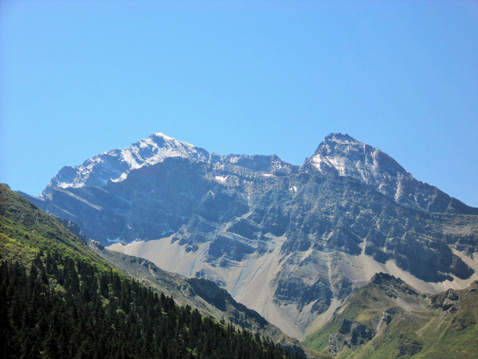
展望台から、南側を望むと、この付近の最高峰、雪宝頂 海抜5588mの頂が見えます

For the south side from an observatory, the top of the highest mountain around here .
Xuebaoding(Snow Mountain Peak)   5,588m above sea level


次回はもあの峰のふもとにある五彩池、黄龍古寺を目指していきます

Next time's pike eel, uh, I'll aim at Wucai(Five-Color)Pond in the base in the back and a Huanglong Ancient Temple.   


2018年8月31日金曜日

沖縄 シリーズ② 基地の島 "Okinawa Series(2) Island in a base."

先日に続いて沖縄シリーズ、那覇空港をもう少しだけ紹介 

Okinawa series and Naha Airport are introduced only a little more following the other day.

那覇空港では航空自衛隊の練習機も飛びまわっています

I'm also flying about a trainer of Japan Air Self-Defense Force at Naha Airport.

機体は T-4


着陸時を後ろから追いかけたらこんな感じ

If I run after a landing the time from the rear, such feeling


次の写真はF-15イーグルの着陸姿勢を撮っています、お尻が重そうですね

The bottom where the landing posture of F-15 eagle is being taken seems heavy for the next picture, doesn't it?


次は、海上保安庁の格納庫

The next is a hangar of the Maritime Safety Agency.

青いヘリコプターは Bell model 206、白いのは??

A blue helicopter  Bell model 206 and a white one?・・??

次の写真は、AgustaWestland AW139


次の写真は ボンバルディア DHC-8 (Q300)

The next picture  Bonn Ball deer  DHC-8 (Q300)?

海上保安庁は常に自衛隊と連携し海の警察活動を遂行しています

The Maritime Safety Agency always cooperates with Japan Self-Defense Forces and is executing the police activity in a sea.


次は宜野湾市へ移動

I move to Ginowan-city next.

次の写真は嘉数高台公園から那覇方面を撮ったものです

The next picture took Naha district from Kakazu hill park.


次の写真はアメリカ海兵隊の普天間基地

The Futenma base where the next picture is U.S. Marines.


移転問題が続いている基地です

A move problem is a following base from the danger by which it's for a plane crash.

並んでいる機体はオスプレイ(V-22)、日本本土では岩国基地に配備されています

The fuselage in line is deployed in Iwakuni base by male play (V-22) and the Japanese mainland.


墜落事故などが多く悪名高い機体ですtが。 もう少しきちんとした整備点検が万全であれば事故は減らせると思います。

Plane crash is the fuselage which has a bad reputation much, t. I think an accident can be reduced when a little more orderly maintenance check is thoroughgoing.


次は、ちょっと前(3年前)に撮った辺野古の海、普天間基地の移転予定地です

まだ、移転問題が解決していないようです

The next is a sea in Henoko taken 3 years before and a move planned site in Futenma base.
Yet, a move problem doesn't seem to settle it.


最近は埋め立て用地がもう取り囲まれており、埋め立てを待つばかりになっているようです、ここも広いサンゴ礁があります

A reclamation site is already surrounded now, reclamation, It's wait, it seems to be, a wide coral reef is also here here.


次の写真はホテル浜比嘉島から撮った浮原島

Uchibarujima where the next picture was taken from hotel Hamahigajima.

ホテルの従業員に尋ねたら米軍の演習用の島だと言う話です

The fact that I say that it's an island for practices of U.S. forces if I ask an employee in a hotel.


2018年8月28日火曜日

黄龍シリーズ① 4000m以上の峠をを超える "Huanglong series(1) More than 4000 m of mountain pass is exceeded."

我々一行は九塞溝での数日間のトレッキングを終え、これからもう一つの世界自然遺産、黄龍へ向かう

We can keep Jiuzhaigou of trekking in a few days at a ditch in a party, and I'll go to the another World Natural Heritage and World Biosphere Reserve Huanglong now.

一大観光地とあってか、道路は整備されている、向こうに見える山脈の向こう側が黄龍

The other side of the cordillera where the they by whom a road is maintained see after whether it matches a grave tourist spot, is a Huanglong.


途中、山間でありながらいくつかの村や街を過ぎる

Though they're the way and a mountain, I cross several villages and town.

意外と大きな建物も点在している

That it's unexpected, a big building is also here and there.

これからきつい上り坂を、我々のマイクロバスはひたすら登っていく

Our mini-bus will climb tight uphill earnestly now.

写真は標高3200mを超えた、グーグル・アースの位置情報では

By the position information by which a picture is a gurgling ground beyond altitude 3200m

32° 46'13.69" N   103° 38'49.42" E  あたりでしょうか

32 deg of north latitude  46'13.69"  East longitude  Is it around the 38'49.42" 103 deg?

またしばらく登っていくと、日本の富士山の標高を超えたあたりで、向こうに白い頂が見えてきました

When it was being climbed for a while again, they were seeing the white top at the vicinity beyond a Japanese altitude in Mt. Fuji.

あの山が、このあたりの最高峰、雪宝頂です

標高5588m

Those mountains are a top around here and the  Xuebao Ding(Snow Mountain Peak).
 Elevation: 5588 m / 18333 ft(Above sea level)


あの雪宝頂の向こう側にもう一つ高い山、王翠峰と言う標高5160mの山があり

There are a high pile and a pile of the altitude 5160m called Jade Peak on the other side of that Xuebao Ding.

その二つの峰の北側、直下に黄龍があります

There is a Huanglong in the north in two of back and falling plumb down.

今まで走ってきた道を振り返ってみていますが、向こうは西側、見えている山は4300mを超える高峰です

I'm looking back to the way which has passed so far, but they're the west side, and a seen mountain is a high peak beyond 4300m.


次の写真の道路の看板が小さく見えますが、あれが峠のピーク、確か4016mぐらいだったと思います、あの峠を越えます

A sign on the road of the next picture looks small, but the peak where that's a mountain pass is over that hardest part where I think it was probably about 4016 m.


次の写真、峠のピークから雪宝頂を望む

I wish for the Xuebao Ding from a peak of the next picture and mountain pass.


この峠のピークから一気に1000m下ったところに黄龍の登山口があります 

There is a starting point for a climb of a Huanglong at the place I went down 1000 m quickly from a peak in this mountain pass.


本格的な黄龍登山は次回からです

Real Huanglong mountaineering is from next time.

Please expect it.